

|
Geographer at the Dept. of Spatial Economics |
|
Martijn Smit |
|
Getting to the VU |
|
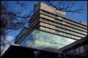
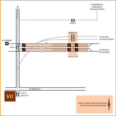
The VU University is very easy to reach. I suggest the following routes: by public transportTake the train to Amsterdam Zuid station. (Direct intercity connections are available from Schiphol, Utrecht, The Hague, Amersfoort, Groningen, and many more stations in the southeast and northeast of the country.) From within Amsterdam, you can take metro 50 or 51 to the Zuid stop. (A quick planner (9292) from your home address to the VU can be found here.) From the station you can walk to the VU in 10 minutes. A map below shows how. Exit the platform at the far end (the west side, where there’s no roof), cross the road carefully, and turn left past the BP gas station to the traffic lights. You are then on the upper left corner of the map below. If it’s raining, or you don’t like walking, take metro 51 from Zuid station in the direction of Westwijk. Get off at the first stop, called De Boelelaan/VU. Walk a few metres backward to the traffic lights (see map below). Standing at the traffic lights, you can clearly see the main entrance of the VU. It’s a big glass structure attached to the solemn concrete building (see picture, top right). On entering, you turn left to reach the main elevators. by carPark your car somewhere sensible and continue by public transport. A special planner which covers car, public transport and any combination of both (using P+R facilities) used to be available here (in Dutch only), and might return in the future. Limited parking around the VU is available, but not free. |
|
tram stop (51 and 5) |
|
entrance |
|
approach |

|
home |
|
Amsterdam Zuid railway station
|


|
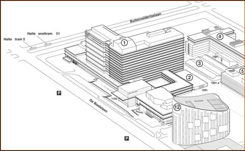
The VU campus: the tall building is the main building (Hoofdgebouw) |
|
North |